


Whit 30 active volcanos, glaciers, rivers, waterfalls, mountains and roughed coastline, Iceland must truly be a landscape photographers dream come true. Just 10 years ago, Iceland was only known to a handful of dedicated landscape photographers, but with Instagram the whole thing exploded. Photographers and tourists are massively visiting Iceland, resulting in huge crowds at the most popular locations, resulting in locations being closed to the public temporarily - that’s the flip side of mass tourism.
The road across Snefellsjökull was covered in a thick layer of clouds so we decided to drive along the coast to reach our goal, Kirkjufell.
The coastline north of Snefellsjökull Nationalpark, with rocks and the subdued vegetation colors offer some great land- and sea scape motives. The gloomy and threatening dark sky, encapsulates in my mind, the rough yet colorful landscape.
Our plan was to photograph Kirkjufell with a the small waterfall in front. But the path to the waterfall was fenced so we couldn´t get close enough, plus constant heavy rain made it impossible. We changed position so I managed to shot the flowing river with Kirkjufell as a backdrop.
Returning from Snefellsjôkull Nationalpark and Kirkjufell the road took a sharp turn before entering our hotel in Borganes.
The Icelandic horse has a long history. They were properly taken to Iceland by Viking Age Scandinavians around 900 AD, and are over time well adapted to the harsh climate.
After spending two days in Borganes we drove towards our next destination, Dyrhólaey and our first stop was Brúarfoss Waterfall. The path to the waterfalls from where we parked reveals a barren landscape with Langjökull as an impressive backdrop.
Brúarfoss is not the typical Icelandic waterfall - it´s many small waterfalls creating one langer waterfall.
Brúarfoss makes up just a small part of Brúar, were the mighty Hvita river runs from the Langjökull glacier.
Our next stop was Pingvellir Nationalpark. It´s on UNESCO´s World Heritage site and it’s the only place in the world were you visually can see the North American and Eurasian tectonic plates meet. The landscape with its dried magma fields, covered in Icelandic moss, surrounded by a bowl of ancient mountain peaks is truly amazing.
Next stop was Gullfoss and Geysir. The Hvitá river travels from Langjökull glacier before cascading 32 meets down, creating Gullfoss. In the summer, approximately 140 cubic meters of water surges down the waterfall every second.
Geysir is a famous hot spring in the geothermal area of Haukadalur Valley, and have lent its name to geysers all around the world. Within Geysir, the powerful Strokkur shoot jets of boiling water from 20 up to 40 meters high.
Our last stop before reaching Dyrhólae was Seljalandsfoss. The close proximity to the Ring Road, Seljalandsfoss with its 69 m drop, is one of Icelands most photographed locations.
The weather in Iceland is very unpredictable - one moment its bright sunshine, the next, grey and overcast.
You feel very humble standing by Seljalandsfoss.
Dyrhólaey was to be our base fore three days. The first day was spend exploring Reynisfjara and Vik. With its impressive sea stacks, basalt collum’s and roaring Atlantic waves, Reynisfjara black beach is considered the most beautiful example of Iceland´s black beaches.
The small church in Vik leis on a hilltop overlooking Reynisfjara black sand beach.Vik is the southernmost village on the Icelandic mainland.
Half on hour from Vik on Sólheimasandur´s black sand beach a United States DC-3 airplane was forced to land In 1973. All crew members survived but the fuselage was abandoned. It´s a one hour hike from the main road, but be prepared for the crowds - it´s a popular Instagram motive.
On our last day before flying home, we left Dyrhólaey early in the morning towards Jökulsårlón glacier lagoon, the mist rolled in from the ocean, creating a wonderfull soft mystical light.
A bit further up the road there was a lake, and with zero wind it provided an excellent chance for some reflection shots.
It was still early morning when we passed a river next to the ring road. The roarring river, the mist and the blue sky incapsulates Iceland at its best.
Passing the bridge at Jökulsårlón glacier lagoon, the weather was not in our favor, It was misty, drizzling with bad visibility, but off course being there, I had to give it a go.
The glacier lagoon is filed with the meltwater from of Europe’s largest ice cap, Vatnajókull. Icebergs breaking from the glacier, can in some cases stand several stories high.
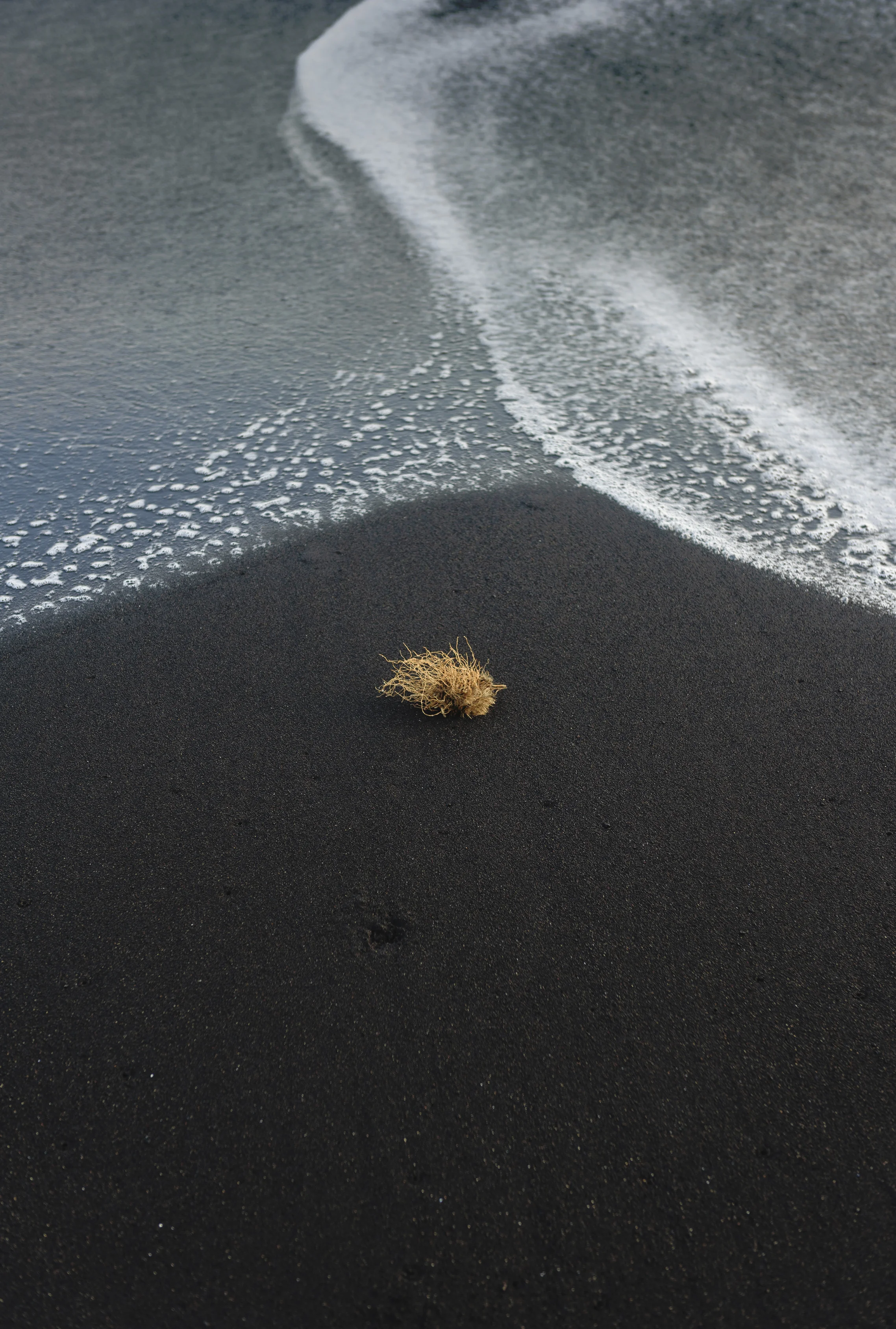
Why Bredamerkursandur is referred to as ´Diamond Beach` are obvious . Massive chunks of ice floating out from the glacier lagoon, is washed up on the black beach sparkling like diamonds.
On our way back from Glacier Lagoon we could see Hvannadalshnjúkur, rising 2100 metre in the distance. We stoped the car, hiked a couple of miles and was rewarded with an amazing view of the mountain and the glacier carved through the landscape.
The enormous scale of the landscape is best illustrated with the person in the bottom of the picture.
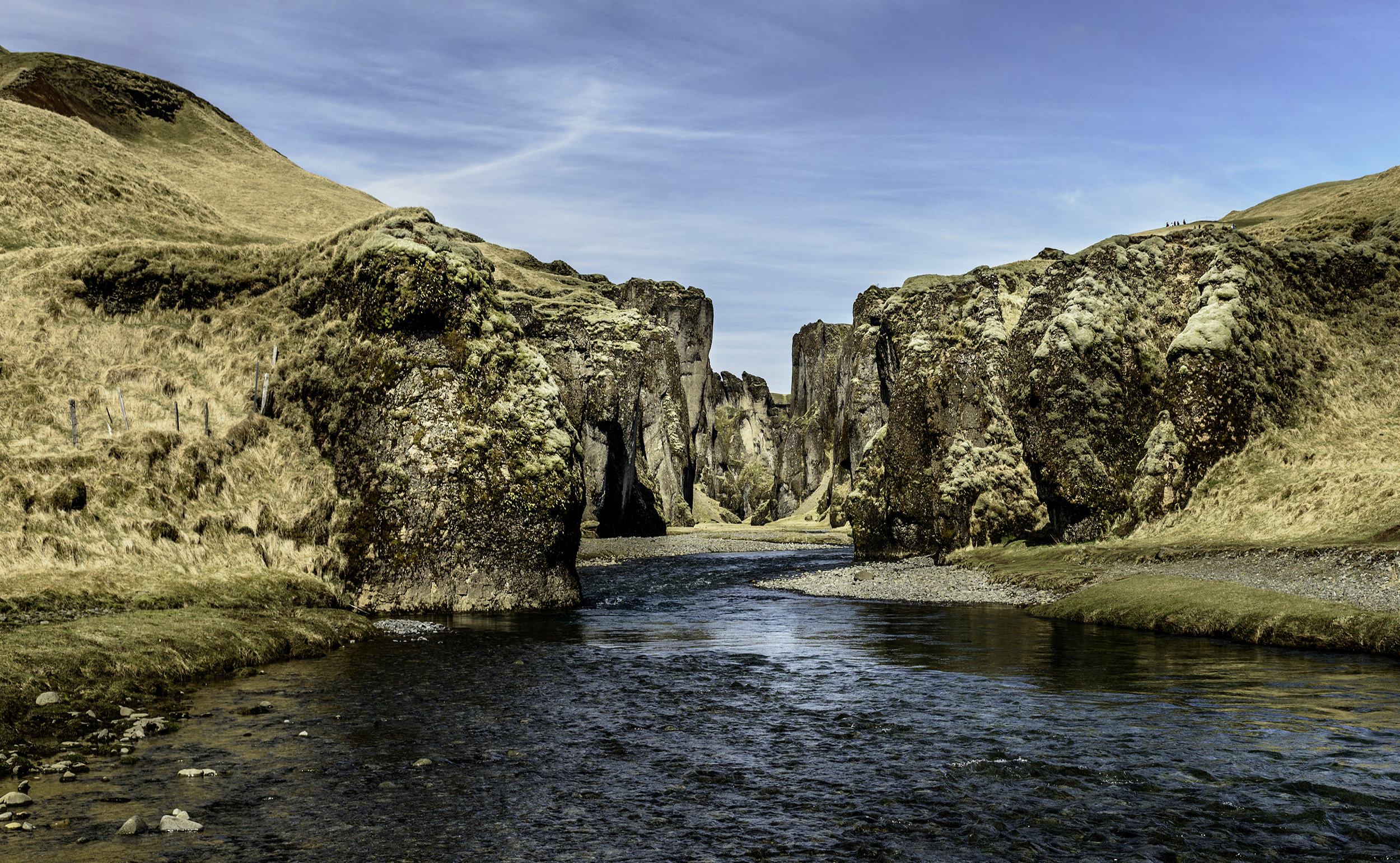
Another stop was Fjadrargljufur Canyon. Fjadrá River flows through the 2 km long and up to 100 m deep stunning and magical Fjadrargljufur Canyon. Normaly soft green moss flourishes in many places, but an abnormal dry season left the canyon quite bare when we were there.
It was our last night, so after dinner we decided to drive up Dyrhólaey Peninsula and check out the view. Driving up there is not for the faint hearted, but when you reach the top, it rewards you with staunning views of Iceland´s south coat, the lighthouse and birdlife.
Black Beach meets the Atlantic Ocean in colorful display.
Dyrhólaey lighthouse.
Dyrhólaey has an abundance of birdlife, with the Atlantic Puffin as the main attraction. Its one of the best places to see them and it´s best from May to September.
Our last night on Iceland was celebrated with an unforgettable sunset.